
")


Single Beam Bathymetry
This is the classic application. The modular design allows the installation of well-known single beam bathymetric instruments (e.g. Leica, Ohmex-Sonarlite, etc). The soundings can be carried out by means of a GPS system in RTK mode or by a totally robotic station with auto-tracking.
All vessels are equipped with a special fitting at the stern capable of housing the echosounder transducer plus a mast with a standard 5/8'' threaded attachment for the GPS antenna or a 360┬░ prism for auto-tracking.
The survey soundings are effected as a completely automatic procedure, based on geo-referenced routes. The waypoint spacing of each route can be determined by the operator (the density of the waypoints depends on the complexity of the route, predictable currents, atmospheric interference etc,.). The duration of each scan, without requiring any intervention by the operator, may extend from the typical 1-2 hours to as much as 8 hours.
In addition to the data acquired by the bathymetric and topographic instrumentation, the system also supplies vessel pitch, roll and yaw measurements which, as a function of the depths measured, can be used for corrections and quality analysis of the performed measurements.
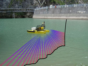
Multi Beam Bathymetry
The growing demand for multi-beam bathymetric surveys in inland waters and the advantage of the simplicity and operational logistics of CatOne vessels, compared to vessels normally engaged in oceanographic surveys, suggested the development and adoption of such systems for aerRobotix products, an activity currently under study.
Leakage detection in irrigation canals
At the Turin Polytechnic's Department of Territory, Environment and Geo-technology Engineering, the development of a system of electrical tomography to pinpoint water leakage in canals is almost complete.
This measuring system, combined with the characteristics of navigation and autonomy of CatOne, represents an interesting solution where monitoring of the water network is required on a large scale and must be repeated at intervals.
Current Measurement prfiling using ACDP
As with other types of sensors, the integration of modern acoustic Doppler profilers (Acoustic Doppler Current Profiler - ADCP) on the vessels of the CatOne family for current measurement profiling is particularly simple thanks to the modular housings built into the hulls. Once again, the advantage of not exposing personnel to the risks of river navigation is obvious.
Compared to systems based on towed or tethered hulls, CatOne offers the flexibility of a system with its own propulsion, maneuvered by a precise and reliable control system, freeing it completely from the usual operational constraint of requiring deployment from a bridge.
Enviromental Considerations
The lack of immersed propellers and rudders, the very shallow draught, low noise levels and the total absence of polluting emissions confer the CatOne family of vessels with maximum environmental compatibility, allowing their operation even in ecologically protected areas. This is evidenced, for example, by the fact that the entire development process was conducted within the Piedmont RegionŌĆÖs Lake Candia Nature Park, notoriously forbidden to powered craft. Discussions are currently under way with the organizations charged with safeguarding the environment, to define the requirements for data collection techniques concerning the chemical / physical state of the water.